Tuesday 8 May 2018

The Forgotten Mahan Singh Garden and his Samadhi in Lahore

22-04-2018


Samadhi
One of the cherished memories from my childhood is the sight of an old structure standing proudly between Naz Cinema and St. John Church as I crossed Mission Road in Lahore. During that time, some of our relatives resided near Civil Lines College in Lahore, and whenever we visited them, we would hire a Tonga from Lahore Railway Station. The usual route would take us through Lakshami Chowk, and occasionally Tonga would turn from Mission Road into Bansaanwala Bazaar, Shah Alam, until finally reaching our last stop, Daata Sahib. It was during these journeys, approximately thirty years ago, that I first became acquainted with this intriguing edifice.

As a child, I couldn't discern the difference between a 'Samadhi' and a 'Mandir.' Whenever I inquired about this particular structure from my father, he would always refer to it as a 'Mandir' and explain that this area was once inhabited by a thriving Hindu community before the Partition of 1947.

Recently, I had the opportunity to visit this edifice. I discovered that it is, in fact, a 'Samadhi' dedicated to Mahan Singh. Situated within the housing quarters of St. John Church, the area encompassing St. John Church and Naz Cinema is also known as "Mahan Singh ka Bagh" (Mahan Singh's Garden).

Although not much historical information is available about Mahan Singh, it is believed that he was an esteemed courtier during the reign of Maharaja Ranjeet Singh. The Maharaja granted him this land as a token of appreciation. When examining historical records, the only name that matches that of Mahan Singh during Maharaja Ranjeet Singh's era is that of Sardar Raja Mahan Singh Mirpuri (d. 1844). Sardar Raja Mahan Singh Mirpuri was a renowned general in the Sikh Khalsa Army and served as the second-in-command to General Sardar Hari Singh Nalwa. He earned the title of Raja from Maharaja Ranjit Singh for his conquests in Haripur, Nowshehra, and Peshawar. The town of Mansehra derives its name from him. During a hunting expedition of Maharaja Ranjit Singh in Lahore, Mahan Singh, who was in search of employment at the time, caught the Maharaja's attention by single-handedly slaying a leopard with his sword. Impressed by his bravery, the Maharaja enlisted him into the army under the renowned General Hari Singh Nalwa.

Mahan Singh played a pivotal role in the battles of Peshawar and Kashmir. He also showed remarkable courage during the siege of Multan in 1818, where he was seriously wounded on two occasions. Eventually, he rose to become the second-in-command to Hari Singh Nalwa. In April 1837, he valiantly defended the Jamrud Fort against Afghan invaders, even concealing the news of Hari Singh Nalwa's demise until reinforcements arrived from Lahore.

Following the death of Hari Singh Nalwa, Mai Desan, his widow adopted Mahan Singh as her son and arranged his marriage into a Mohan family from Gujranwala, following Muhiyal traditions. Tragically, Sardar Raja Mahan Singh met his untimely demise in 1844 when mutiny erupted within the Sikh Khalsa Army, and he was murdered by his own soldiers.

Regrettably, the Samadhi is currently in a state of disrepair and is being used for storage purposes. Nonetheless, traces of fresco artwork can still be observed within the premises. The approximate coordinates of this site are 31°34'4.62"N, 74°19'13.55"E

Another view of Samadhi

Inside View of Samadhi

Inside View of Samadhi

Inside Roof 

 Another View of Samadhi
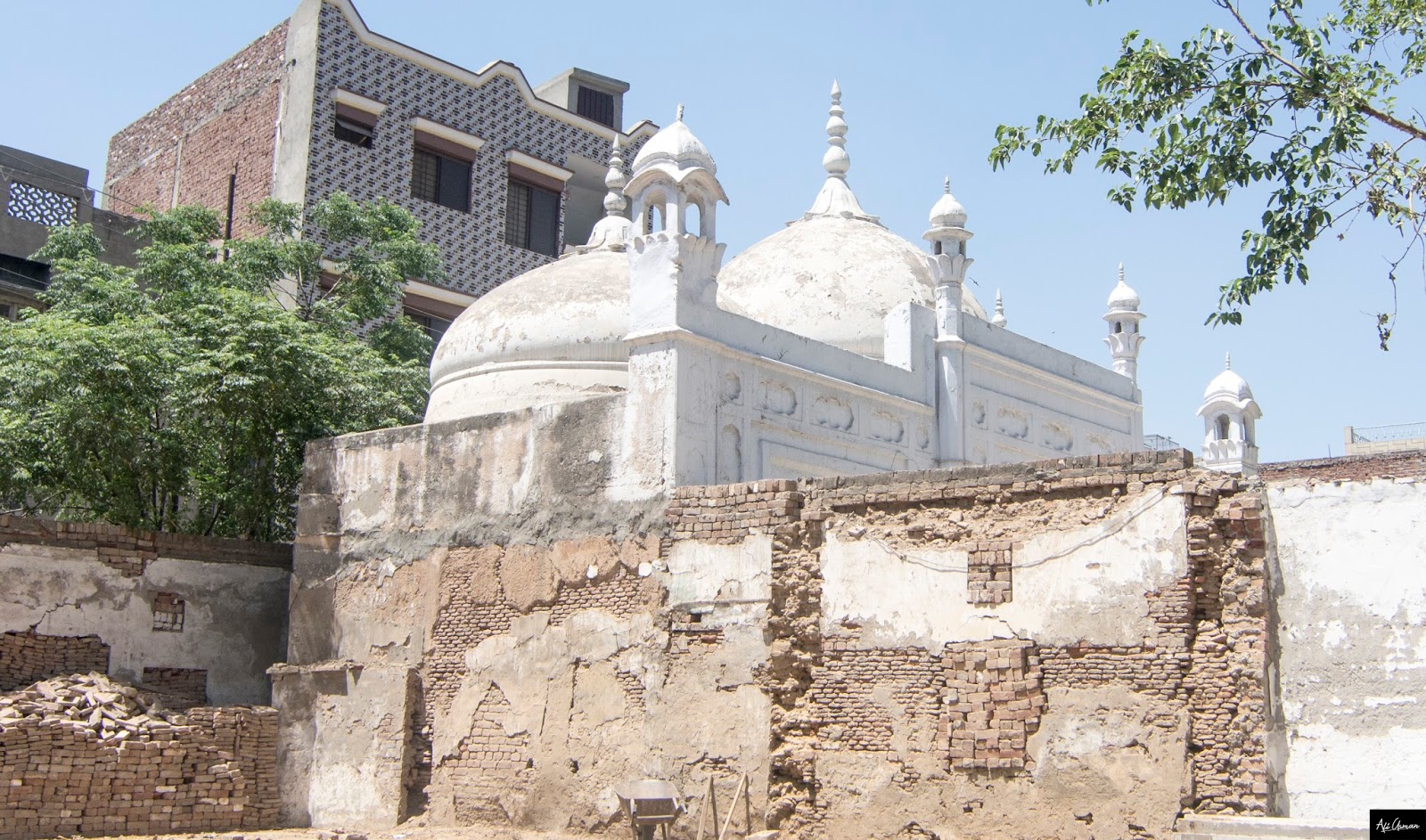


This place  was used to be Mahan Singh Garden
 This place used to be Mahan Singh Garden

Google Earth Location View


Sunday 6 May 2018

BURJ MALKA HANS


06-04-2018

It is square burnt brick burj (bastion) supported with mud bricks. A staircase is located on north side. It is located outside the village of Malka Hans in fields. The burj seems to be part of fort boundary wall, with passage of time bricks from walls taken for construction of houses in nearby villages. 

No, history has been found about this structure. The old villagers told it is standing in fields for centuries. Also it is told some paranormal activities have been observed near this edifice. That’s the only reason which saved it  from destruction.


Special thanks to Pakistan Archaeological department who have documented this place. However, I wish they have done some effort to preserve this place as well. 

Thursday 3 May 2018

Nawab Raza Ali Khan and his Red Bungalow in Lahore


22-04-18

Fateh Ali Khan, a Kazilbash Nawab, led the distinguished Turkish family of the Kazilbash tribe, which initially migrated from the western Caspian coast (now part of Russian territories) alongside Nadir Shah, the renowned invader of India. They settled in Kabul, wielding significant influence and authority while holding hereditary estates.

Several family members, while under their Eastern Master, provided invaluable assistance to the government during the First Afghan Campaign.

In 1839, during the British Army's initial entry into Kabul, Ali Raza Khan, an ancestor of the current Nawab, rendered invaluable services to the government, particularly in the realm of commissariat supply. Later, in 1857, he made substantial sacrifices while raising a substantial force. In recognition of these deeds, he was granted a talukdari comprising 147 villages, yielding an annual income of around Rs. 15,000. In 1864, he was bestowed with the hereditary title of Nawab and settled in Lahore.

The present bungalow is believed to have been constructed by Nawab Ali Raza Khan. Its approximate location is 31°34'6.35"N 74°20'4.06"E.


 Front Elevation

 Arches

Side Elevation 

Tuesday 1 May 2018

The Hidden Mosque of Saleh Sindhi of 17TH Century


22-04-2018
(All pictures are taken by me, please respect copyright)

Saleh Sindhi Mosque is hidden on the premises of a private property on Shahrah-e-Bin Badis (earlier Empress Road). As you proceed north on the road, just past the St. Anthony's (Don Bosco) Church and across from the Pakistan Railway Headquarters, you will find a gate on your left into a large compound known as Nawab Palace, belonging to Lahore's well known Nawab Qizilbash family.

Side Elevation

From the main road you will not be able to view this 17th century Shahjahani mosque, since it lies hidden behind foliage at the rear of the interesting British-period brick mansion. Since it is private property, you will need permission to enter the grounds and then ask to view the ancient mosque. The caretakers are normally very cooperative and will accompany you to the rear of the sprawling compound.

Side Elevation

The mosque is impressive in its pristine purity of whitewashed surfaces. No evidence of any decoration is visible today in this single-aisle 3-bay mosque. The original simple cusped arches leading into the prayer chamber today carry modern-day doors to secure the mosque. Even so, there is no major intervention or tampering visible in the historic structure, except in the use of plaster in the lower part of walls in a vain attempt to arrest the rising damp. This mosque appears to be one of the few Mughal mosques which have not suffered large-scale renovation/restoration. Thus, it is invaluable for the study of original mosque structures of the period. The usual 3-dome arrangement, with a larger dome in the middle flanked by two smaller domes, all topped by pinnacles is graceful in its execution. The courtyard, no longer very large, has been redone and the brick flooring mentioned by Latif is no longer extant. Kanhaiya Lal believes that the mosque once existed in the midst of a large garden.

View from Adjacent Street

Front Elevation

Historian Latif credits Muhammed Saleh Sindhi, with the construction of the mosque. Muhammed Saleh, a wealthy amir (noble) at the royal court, was appointed diwan by the governor of Lahore during Emperor Shah Jahan's reign. Saleh was a nephew of Haji Sewai, after whom the area was once known as Mohallah Sewai. As was the fate of many Muslim historic structures, this mosque too did duty as an arsenal and powder magazine during the reign of Maharaja Ranjit Singh. However, luckily, it escaped large-scale damage, and after annexation by the British was repaired by Nawab Ali Raza Khan Qizilbash and became a part of his large estate.

Google Earth Imagery 


Thursday 26 April 2018

Sher Shah Suri Mosque Shergarh


06-03-2018

30°49'51.21"N
73°44'21.66"E

The Tarikh-i-Sher Shahi (history of Sher Shah) dating 1580 CE, is a historical work compiled by Abbas Khan Sarwan. In this book Abbas highlighted that, after few years of Conquering of Multan by Afghans; Sher Shah Suri Nominated Fateh Jang Khan Governor of Multan. Fateh Jang Khan, named the town of Shergarh after the Afghan ruler of IndiaSher Shah Suri, who built a mud fort in town.

Fateh Jang Khan also constructed a Jamia Mosque in Shergarh Town the mosque is known as ‘Sher Shah Suri Mosque’. This mosque constructed in middle of tenth Hijri. Most of the structure of this mosque collapsed in 1955 and turned into ruins.  In 1958 the last two entrance gates located on left portions were also fallen.  


The original dimension of mosque was 100 feet in length and 25 feet in width.  It has five entrance doors and also consists of five domes in roof. The middle dome was of larger diameter and height.  Four Octagonal columns of 30 feet height constructed on each corner of mosque. There was stairs constructed on south and north side of mosque. The central courtyard was 30 feet in length and 100 feet in width. The internal walls of mosque were decorated with floral artwork. There was also a well constructed in courtyard.
The new mosque rebuilt on 11th march 1977 by the Auqaf Department.


Monday 23 April 2018

Pipplan Buddhist Monastery


29-03-18
The approximate location of this site is 33°45'56.66"N, 72°51'57.95"E.
Piplan, the ancient Buddhist monastic establishment in Taxila that was named for the thick peepal trees of the area, is a Buddhist archaeological jewel located in a calm valley that has stayed hidden from local and foreign tourists and the public, despite its unique landscape.
PIPLAN IS ANCIENT BUDDHIST MONASTERY IS ON UNESCO WORLD   
HERITAGE LIST AS A PROTECTED ANTIQUITY  
The ancient site lies at the foot of the hills between Mohra Maradu and Julian, the ancient Taxila university. According to Dr Mohammad Ashraf, the former director of the Taxila Institute of Asian Civilisation, the site was excavated in 1923-24, under Sir John Marshall, the director general of the Archaeological Survey of India.
 A WELL PRESERVED VOTIVE STUPA BUILT OF ASHLAR DIAPOR MASONARY IN PIPLAN
Department of Archaeology and Museums Deputy Director Abdul Ghafour Lone said that later, study papers had revealed that archaeologists during the excavation had found the site belonged to two different periods.
Studies conducted by the archaeologists found that to the east is a courtyard of a monastery dating back to the late Partian or early Kushan times. It consists of an open quadrangle in the centre, with a range of cells on all four sides. Mr Lone added that in the middle of the courtyard is the basement of a square stupa.

Former archaeology department deputy director Bahadur Khan explained that the early monastery, which was constructed of diaper masonry, fell to ruin before the 5th century, and a second monastery was later constructed on the western side.
Mr Khan said that according to the research, the second monastery was constructed from heavy, semi-ashlar masonry, and was exceptionally well-preserved. The ruins of the second monastery revealed that it comprised a court of cells on the north side, with a hall of assembly, kitchen and refectory to the south and a converted stupa to the east.
 A WELL PRESERVED VOTIVE STUPA BUILT OF ASHLAR DIAPOR MASONARY IN     PIPLAN
The cells were built on two storeys, and as per the traditional Gandharan style of architecture, consisted of an open quadrangle with cells for monks on all four sides and a pillared veranda.
According to Mr Lone, a now dilapidated stupa in a cell was discovered in the southeast corner of the monastery. The floor of the stupa and the cell in which it stands is around 2ft below the rest of the monastery, leaving little doubt among the archaeologists and researchers that the stupa was originally built in one of the cells of the earlier, Kushan-era monastery and then incorporated into the later one.
SMALL STUPA
A still intact 8ft high stupa stands in a chamber of the monastery. It was tradition to build a memorial stupa inside a cell after the prinirvana (death of a venerable monk). This stupa rises to three diminishing tires, the topmost surmounted by a dome and originally crowned by an umbrella, decorated with lotus rosettes and images of Buddha, while at the base of the dome is a series of seated Buddhas. However, due to a lack of preservation and conservation, the stupa is in shambles.
REMAINS OF 8 FT HIGH STUPA STAND IN CHAMBER OF MONASTERY 
According to Mr Lone, only one excavation was carried out by British archaeologists before partition, which recovered 26 coins featuring Azes, Kadphises, Kanishka, Vasudeva and Indo-Sasanian rulers. He said the study had revealed that by the end of the 5th century, the Buddhist site met the same fate as its contemporary monastic settlements in the region, resulting in gradual decay due to human and natural agents.
COURT 
Piplan has been added to the Unesco World Heritage List of the convention concerning the protection of the world’s cultural and natural heritage, while the Pakistani government has declared the site a ‘protected antiquity’ under the 1975 antiquities act.

 SMALL STUPA

GOOGLE EARTH VIEW 

Thursday 19 April 2018

HARAPPA OLD MOSQUE

04-04-2018
This ruined mosque appears to have been built in the Mughal period (1526-1707 AD)originally referred to as an Eid-Garh.This structure was probably built as a place for prayer to commemorations of a renowned person from the local community and it may be associated with the tomb of Baba Noor Shah Wail to the west. 

The mosque measures 12 meters north-south and may have had a rectangular shape, no indication of the roof have been found. It has five arches in the western wall which are found only in a few other early mosques generally associated with family burial structures. The mosque was constructed with reused Harappan bricks and is built on the top of a massive city wall of the Harappan period (2600-1900 B.C) that enclosed the part of the site called Mound 'AB": The Harappan city wall was constructed of mud bricks with baked bricks facing and superstructures. Conservation of the mosque began after detailed documentation of the original structure and excavation of the adjacent areas. Decayed bricks were replaced and a supporting foundation revetment was built along the existing walls. 

The preserved walls have been strengthened by re-pointing with kanker lime plaster and the arches were constructed Clay plaster has been applied over the eastern face to limit further damage to the underlying Harappan period structures until additional conservation measures can be implemented. Excavation and conservation is made by  Dr. R.H  .Meadow and Dr. J.M.


Tuesday 17 April 2018

Bhir Mound

33°44'35.95"N   72°49'17.48"E
290318
Excavations by Marshall at the Bhir mound, the earliest city, reached the natural substrate at a depth of about 5.5 meters (18 ft.) and encountered the remains of four superimposed structures. The earliest, of which little is known because of its depth and destruction by later construction activity, dates to the fifth century b. c.e. at the latest. The second was in occupation during the fourth century b. c.e. and would have witnessed the arrival of Alexander the Great. The third phase corresponds to the period of Mau-ryan control, and the last probably belongs to the period after the decline of the Mauryas and the arrival of the bac-TRIAN GREEKS in the second century b. c.e. The excavations revealed streets, lanes, and domestic houses. The quality of the stone masonry developed over time from fairly rough to a much more compact form, and the walls were covered in a mud plaster strengthened with straw.

Most of the available plans derive from the third period, the Mauryan city The layout of the streets and houses is irregular. It is evident that the main street and various squares were retained throughout the life of the city, whereas houses were leveled and rebuilt on occasion, but on the same site and often following a plan similar to that used for their predecessors. Some lanes branching off the main streets are very narrow. The drains running along the main street were to take rainwater. There was no city sewage system, but each house was equipped with a deep pit to receive human waste. Such latrines were also placed in public squares. There were several types of latrines. They have in common a deep circular well-like hole extending up to seven meters (23 ft.) into the ground. Some were filled with broken pottery shards to allow wastes to filter downward. Others were lined with ceramic rings: One of these held 14 such liners, each 65 centimeters (26 in.) wide. A third type was filled with large ceramic jars one on top of the other, each having the base removed to form one continuous tube. Large stone rubbish bins were also strategically placed in public areas, and excavations revealed broken pottery and animal bones. The houses were a series of large rooms grouped around a courtyard. windows looking onto the street were tall but very narrow. Many rooms were small, and others had a street frontage and were probably shops. One appears to have been the business of a shell worker, since Marshall found much cut shell within.

As might be expected in the excavation of so large an area of an ancient city, many artifacts were recovered. Beads had many forms, with a preference for glass, car-nelian, and agate. Other semiprecious stones included onyx, amethyst, beryl, and garnet. A remarkable hoard of 1,167 silver coins was discovered in the second city, including a silver Persian coin and two coins of Alexander the Great. Among the bronzes, particular attention is given to a third-century b. c.e. bowl made of an alloy containing 21.55 percent tin. This alloy and the shape of the vessel recall those found in the Thai cemetery of ban don TA PHET. Iron was used for weapons, particularly arrowheads, spears, and daggers; for tools such as chisels, adzes, and tongs; nails for construction purposes; and for hoes.


Apsidal Temple Sirkap

290318
The building that is known as the Apsidal Temple is the largest sanctuary of Sirkap, measuring about 70 by 40 meters (230 by 130 ft) (by contrast: the Parthenon in Athens is 70 by 31 meters (230 by 102 ft)). The Apsidal Temple consists of a square nave with several rooms, used by the Buddhist monks, and a circular room, which gives the building its apsidal shape. After the earthquake that destroyed the city in c. 30 AD, the Buddhist shrine was built in a spacious courtyard. The round part was probably in use for a small stupa, but no traces of it remain. Some carvings were probably done by an artist from Greece


Sirkap Jain Temple

290318
A.G. Lone, an archaeologist who discovered BC-era lamps from a Jain temple in the area during 2004 and 2005 at Sirkap. Jain temples and tirtha (pilgrimage sites) are present throughout the Indian subcontinent, many of which were built several hundred years ago


Friday 13 April 2018

Waris Shah Mosque Malka Hans Pakpattan


The approximate location of this site is  30°25'27.91"N,  73°16'28.92"E
060418

Waris Shah was born in Jandiala Sher Khan, Punjab, present-day Pakistan into a reputed Sayyid family and was a descendant of Sayyid Muhammad Al-Makki through his son Sayyid Badruddin.[His father's name was Gulsher Shah. Waris's parents are said to have died when he was young. Waris acknowledged himself as a disciple of an ustad from Kasur, namely Hafiz Ghulam Murtaza from whom he received his education. 

After completing education Waris moved to Malka Hans, a village twelve kilometres north of Pakpattan. Here he resided in a small room, adjacent to a historic mosque now called Masjid Waris Shah, until his death

 Elevation
 interior dome view
 arches

 front elevation
waris shah Hujra(room)

Thursday 12 April 2018

The oldest Stupa in Indian Sub-continent


One round Stupa is present at Sirkap. It is one of the oldest Stupas in the Indian-Subcontinent. It is assumed that this Stupa was uprooted and thrown to its present location by a strong earthquake in the 1st century AD. When the new city was built later, the Stupa was kept by building a protecting wall around it.


Wednesday 11 April 2018

1st Century BC Grecian Style Stupa at Sirkap Taxila


290318
The location of the site is 33.755711' N, 72.829391' E

A special Stupa at Taxila is from first century BCE having four Corinthian columns, a quintessential Grecian style of architecture – stand tall at the Sirkap.

There is no niche and stone carving present on front platform, which made it look different from neighboring double headed eagle Stupa.  In platform at corner and along the stairs fluted posts are present. This is common feature in Greek edifices.

Taxila being destroyed three times by earth quake, the super structure of this stupa supposed to be damaged badly after 1st A.D earth quake

The remnant of four columns on platform must have been designed to support super structure.  

 STUPA
 CORNER COLUMNS AND VERTICLE FLUTED POSTS
 CORNER COLUMNS