Following the footsteps of Alexander Cunningham
Date of visit: -
March 08, 2018
All Pictures are
owned
Reference is taken from
the book ‘The Ancient Geography of India’ by Sir Alexander Cunningham.
A few years back, I read notes of Sir Alexander Cunningham on Asarur the probable ancient Buddhist
capital in Panjab before the Muhammadan period, which was visited by famous Chinese
pilgrim Huen Tsang in 633 AD.
I want to visit this
site of great historical importance for quite some time but know very little about the
exact location of this place. However,
with this incomplete information about the location, I decided to visit Khanqah Dogran to
find this site. Fortunately able to find it after a few hours of wandering and with help of a local's guidance.
 |
| The View of Mound |
Sir Alexander Cunningham
was known as the father of the Archaeological Survey of India which he founded
and served as the first director between 1861 to 1865. He spent sixty years in
India in the Army and achieved distinction as an archaeologist and scholar of the ancient history and geography of India.
Cunningham was a keen
student of Huen Tsang and Fa Hein(Chinese monks who came to India in the 7th
and 5th centuries CE, respectively, in search of Buddhist scripture) and
decided to retrace the journey of Huen Tsang to identify every single place
mentioned by him.
His book, ‘The Ancient
Geography of India’ refers here to India's Buddhist period up to the seventh
century CE, during which time Buddhism was the subcontinent's dominant
religion. In this work, he draws on material ranging from the campaigns of
Alexander the Great to the travels of the seventh-century Buddhist pilgrim Huen
Tsang, who recorded much about India's geographical, political, religious, and
cultural landscape.
A mound near the modern
village of Asarur (Now Khangah Dogran tahsil of Gujranwala District, Punjab has
been identified by Cunningham as the site of the ancient capital of Panjab. It
is visited by Hiuen Tsiang in 630 AD.
The city was then one of
great importance and is said by the Chinese pilgrim to have been 3 miles in
circuit, a measurement which agrees well enough with the ruins still
existing. The antiquity claimed for the place is confirmed by a large number of bricks, 18 by 10 by 3 inches, which are found all over the ruins, and by the great numbers of Indo-Scythian coins discovered after heavy rain.
Its history therefore indeed reaches back to the beginning of the Christian
era. The ruins consist of an extensive mound, 15,600 feet, or nearly 3 miles,
in the circuit. The highest point is in the northwest quarter, where the mound
rises to 59 feet above the fields. This part, which Cunningham takes to have
been the ancient palace, is 600 feet long and 400 feet broad, and quite regular
in shape. It contains an old well, 21 feet in diameter, which has not been used
for many years and is now dry. The place is surrounded by a line of large
mounds about 25 feet in height, and 8,100 feet, or \\ miles, in the circuit, which
were the strongholds or citadel of the place. The mounds are round and
prominent, as the ruins of large towers or bastions. On the east and south
sides of the citadel, the mass of ruins sinks to 10 and 15 feet in height, but
it is twice the size of the citadel and is no doubt the remains of the old
city.
 |
| The Mound where once citadel present |
 |
| Clearly can see old bricks in mound walls |
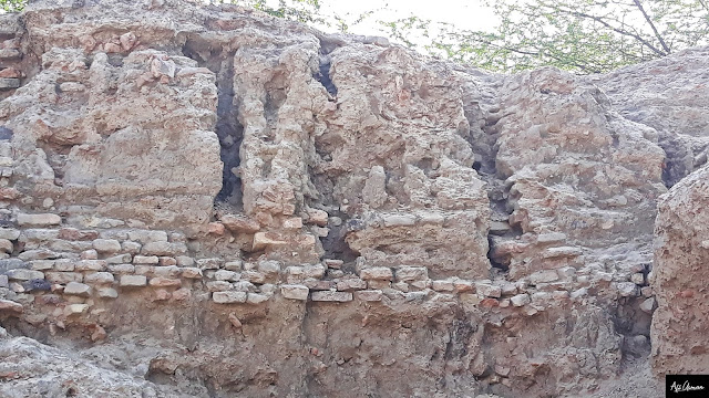 |
| Old Bricks of the Buddhist Era |
 |
| Old Bricks of the Buddhist Era at the mound |
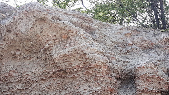 |
| Debris at Mound |
 |
| Another picture of Debris |
 |
| Another Scene of Mound from fields |
 |
| Mound |
 |
| Mound |
 |
| Mound |
 |
| Mound |
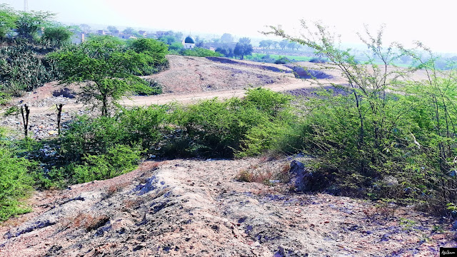 |
| Most of part of mound now converted into fields and residential areas of the village |
 |
| Mound |
 |
| An unknown Shrine was constructed on top of the Mound |
 |
| Another view of Mound |
There are no visible
traces of any ancient buildings, as all the surface bricks have been long ago
carried off to the neighboring shrine of Ugah Shah at Khangah Masrur on the
road from Lahore to Pindf Bhattian;
but among the old bricks forming the surrounding wall of the mosque,
Cunningham found three molded in different patterns, which could only have
belonged to buildings of some importance.
 |
| Mosque constructed of old bricks extracted from Ancient Mound. The mosque is not in used now |
 |
| Another view of Mound |
 |
| View of Mosque from Inside |
 |
| Another view of the Mosque |
 |
| Another View of Mosque |
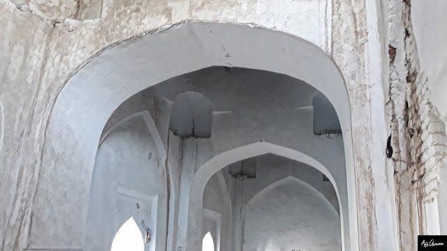 |
| Another View of Mosque |
 |
| Another View of Mosque |
He found also a wedge-shaped
brick, 15 inches long and 3 inches thick. This must have been made for a stupa,
or a well, but most probably for the latter, as the existing well is 2 1 feet
in diameter. The modern village of Asarur contains only forty-five houses. At
the time of Hiuen Tsiang's visit, there were ten monasteries, but very few
Buddhists and the mass of the people worshipped the Brah- maniacal gods.
North-east of the town, at 10 //, or nearly 2 miles, was a stupa of Asoka, 200
feet in height, which marked the spot where Buddha had halted, and which was
said to contain a large number of his relics. This stupa General Cunningham
identifies with the little mound of Salar, near Thatta Saiyidan, just 2 miles
to the north of Asarur.


