Date of Visit:- 31-01-2021
(All pictures and writeup text used in this blog, is author property, kindly respect copyrights)
 |
| Temples and Devotee's Hall, All doors and windows are still intact |
My dear historian friend, Adnan from Depalpur, had
been urging me to visit Mandi Ahmadabad for some time now.
Located in District Okara, within Tehsil Depalpur,
Mandi Ahmadabad is a town situated eight kilometers from the India/Pakistan
international border and 140 kilometers from Lahore. It is positioned near the
Bambanwala-Ravi-Bedian Canal (BRB Canal), which branches off from the upper
Chenab canal near Bambanwala village. The BRB Canal runs southeast, close to
the India-Pakistan border, and then proceeds south, parallel to the border,
passing through Mandi Ahmadabad and ending near Basirpur. Additionally, the
River Sutlej flows about four kilometers southeast of this town.
Originally known as Mandi Hira Singh, this town was
renamed in 1993 by the Government of Punjab in honor of Mirza Ahmad Baig, a
well-known local politician.
Adnan informed me about two pre-partition Hindu
temples that still exist in this town. These temples are easily visible from
outside the town and appear identical from a distance. They are situated within
the premises of the Government Higher Secondary School for Boys in Mandi
Ahmadabad.
During my visit, I was hosted by Rafi Sehrai Sahib,
a schoolteacher by profession and a renowned Punjabi poet. He shared with us
that before the partition of 1947, a considerable number of Hindu and Sikh
families lived in Mandi Ahmadabad. The school building, which now houses the
temples, was a large Hindu temple complex at that time.
The architectural style of these temples is not
significantly different from similar structures found elsewhere in Pakistan.
The temples predominantly follow the Nagara style, which originated in northern
India.
Both temples consist of a raised square sanctum,
designed to house the deity's statue. The interior of the temple features a
hyperbolic roof, with embrasures on each wall to allow natural light to enter.
Above the square sanctum, the main temple spire
(also known as a shikhara) is constructed. It is worth noting that although the
two temples may appear similar from a distance, their spire designs differ. The
spire consists of three parts.
Temple 1:
The first part is a square platform with design
projections on all four sides.
Above it, the second part is raised, also square in
design, but with different styles of wall, projections compared to the first
part. The third part, situated
above the second part, is square at the bottom and merges into a curvilinear
top. This temple is an example
of a "homogenous" shikhara, featuring four faces of similar design
and pattern, with all elements smoothly curving up the face.
Temple 2:
The first part is a square platform with design
projections on all four sides. The second part is circular in construction,
with wall projections along the circumference. The third part of the tower is
also circular.
It is believed that the difference in the design of
these two temples might be due to the fact that they housed deities of
different genders. These two temples are taller than any others I have seen in
Pakistan.
Surrounding these temples is a hall measuring 40 x
64 feet, which was used by devotees. The hall also contains a mezzanine floor
where female visitors used to sit.
Unlike many other Hindu buildings in Pakistan, the
temples in Ahmadabad are well-preserved by the school authorities. The original
wooden doors and windows of the building can still be seen.
These temples were constructed around the year
1945.
In my quest for historical references about Hira
Singh, the man after whom this town was originally named, I found limited
information. My host, Rafi Sahib, informed me that Hira Singh was a Sikh
chieftain of the area who had given his land to the British for the
construction of a railway line, which led to the town being named after him.
 |
| Sanctum, room for placing Diety |
 |
| A cabinet where diety was placed |
 |
| Hall for Devotee, Mezzanine floor is visible |
 |
| Space between two temples sanctum |
 |
| Two Sanctum view from Hall of devotees now used as class room |
 |
| Another view of Hall of Devotee |
 |
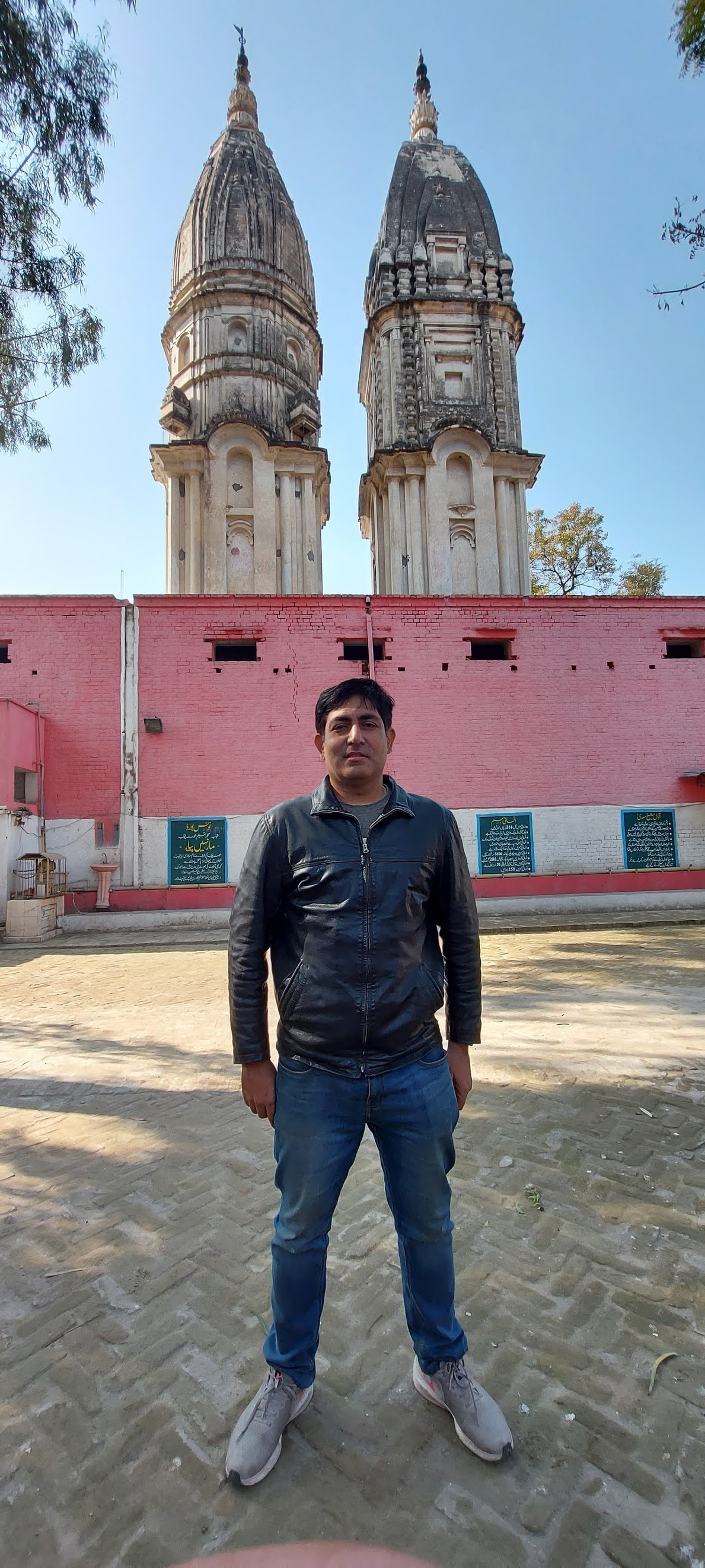
| Standing with my host Rafi Seherai Sehab |