Monday, 2 April 2018

Bhamala Stupa


Largest ‘death of Buddha’ statue and first double halo statue found in Gandhara


29-03-2018
33°49'58.52"N
72°58'34.92"E

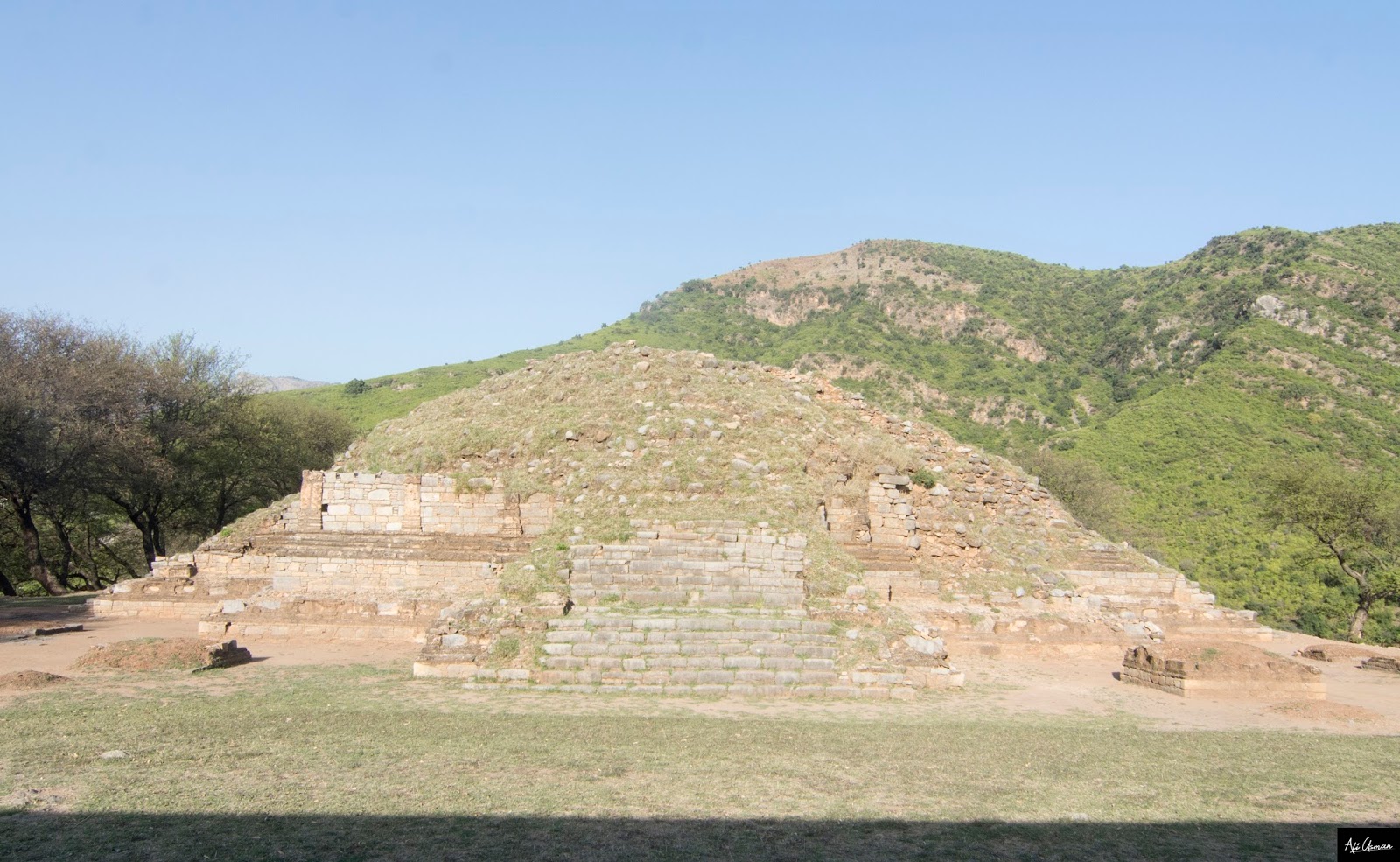
Bhamala Stupa is a ruined Buddhist stupa and National Heritage Site near HaripurPakistan. The Stupa is different from other stupas found in Gandhara. The ruins date back to the 4th century CE. The ruins are situated very near to the Khanpur Dam. The stupa is cross shaped and looks like an Aztec Pyramid. Bhamala stupa is an archaeological site and is also known as Bhamala Buddhist Complex.

Sir John Marshal first excavated the site in the late 1920s and early 1930s but The site was never studied in depth again. It is nominated at UNESCO World Heritage Sites. The nomination lead to the restoration of the ruins (mainly the Stupa). The site , as of June 2015, is under the control of Department of Archaeology and Museums, Government of Khyber Pakhtunkhwa, Government of Pakistan. The site is believed to be one of the best preserved sites in the Taxila Valley

According to the current understandings, the shape of main stupa is cruciform and it is the biggest surviving example of this shape in Taxila and Gandhara region. There are about nineteen but small votive stupas in courtyard surrounding the main stupa

According to archaeologists this discovery is the largest statue ever found in Gandhara depicting the death of Buddha as well as a ‘double-halo’ Buddha statue, the first of its kind to have been found at the Bhamala Stupa site.
The rare discovery was made during excavations at the Buddhist stupa and monastery dating back to 4th century AD.
According to Dr Abdul Samad, Khyber Pakhtunkhwa director, Department of Archaeology and Museums,  this latest discoveries by the archaeologists have opened new chapters in the history of the ancient Taxila valley civilisation.
“This is one of the few sites in the world to have the cruciform Stupa which was reserved for Buddha himself.”
The death of the Buddha scene is known as ‘Maha Pari Nirvana’. The statue depicting the scene, measures 14 metres in length, and is the largest ever statue of its kind found in the archaeological history of Gandhara civilisation. The image is placed on a 15 metre long platform.
Buddha’s head is missing as the site appears to have been targeted by illegal treasure hunters.
“Other parts of the statue such as the left leg and arms were also found in a damaged condition,” he said.
Other images in terracotta have been found near the Par Nirvana scene. Pari Nirvana scene was exposed from a long chamber to the west of the main Stupa facing towards east. He added that access to this chamber is given through three openings at regular intervals. The chamber is made of stone in semi ashlars masonry. This statue of Buddha with double halos was unique and such a statue had never been found at this site. In the past statues, heads of Buddha statues and coins from the Kushan period had been found at the site.
“In the first leg of this excavation, archaeologists have opened a new chapter in the archaeological history of the Taxila valley. Through the recent discoveries, it has been confirmed that the site dates back to 3rd century CE. Recently discovered Buddha heads are made in baked soil which dates to the third century, rejecting archaeologist John Marshal’s claim from 1930 that the site was from 12th century CE.”
During this leg of excavations, other relics such as a carnelian seal depicting what appears to be the Gaja Lakshmi deity, one of the forms of Hindu goddess Ashta Lakshmi have been discovered. Other relics with Kashmiri influence have added new dimensions to what we know about these ancient civilizations. Several terracotta and stucco Buddha statues and copper coins were discovered at this site which date back to the Kidara-Kushan period (4 to 5 CE). This indicates that Bhamala was not isolated from main Taxila. Material found in Bhamala could improve our understanding of Buddhist culture, development and contact in this region.
The success of the Bhamala Stupa study would also encourage other archaeologists to come to Pakistan.
The Bhamala complex was different from other sites in Taxila valley.
The stupa, shaped like a cross, resembles Aztec Pyramids and such constructions had only been found in Kashmir, in the past. Main stupa was cruciform and there were about 19 small votive stupas in the courtyard surrounding the main stupa.
During the recent excavation, a total of 510 relics were discovered, which included terracotta, stucco sculptures as well as iron objects including nails, hooks, door fittings, hair clips, copper artifacts and 14 coins from the late Kushan period.

 main stupa i 

main stupa is cruciform 
Buddhist  monastery
 Buddhist  monastery


 double-halo’ Buddha statue, 
 main stupa is cruciform 
main stupa is cruciform 

Monday, 26 February 2018

REMNANTS OF ARCH BRIDGE of MUGHAL ERA on CHHOTI DEGH & ITS STORY of DEMISE

 February 26, 2018
by Ali Usman Baig

A few years ago, I had the opportunity to visit a remarkable bridge that dated back 400 years to the Mughal Era. This architectural marvel was situated on Degh Nala and captured my interest after reading an extensive article about it by Sir Salman Rasheed. Intriguingly, Sir Salman Rasheed's article also mentioned another Mughal-era bridge located on a branch of the Degh known as the Chhoti or Lesser Degh, not far to the west.

For a considerable period, I struggled to pinpoint the exact location of this place. However, after much effort, I finally succeeded and visited the site last Sunday. As I arrived, I noticed the remnants of the collapsed bridge scattered across the stream, a stark reminder of its former grandeur.

The length of the bridge was measured to be 30 meters, identical to the Mughal Era Bridge situated on the main Degh River. It was an arch bridge, featuring four arches with a center-to-center distance of 7.5 meters. Construction of the bridge is believed to have taken place in the later decades of the sixteenth century.

An analysis of the chemical and mineral composition of the Mughal mortar renders, and plaster from the seventeenth century revealed the presence of coarse materials such as bricks, kankar pieces, and slag, along with fine aggregates like river sand. These materials were typically combined with a calcite lime binder. The specific ratio of binder to aggregate varied depending on the functional requirements of each masonry unit. The chemical composition, both major and trace elements, indicated the use of locally available raw materials in the construction of these historical monuments. In the current bridge, the construction comprised Nanak Shahi bricks internally reinforced and filled with calcite lime mortar.

Arch bridges, which have been utilized for over 3000 years, remain one of the most popular bridge designs. During the Roman Empire, stone and wood arch bridges gained significant popularity, with architects successfully constructing over 1000 stone arch bridges across Europe, Asia, and North Africa. Remarkably, many of these bridges have endured to this day. Contrary to the belief that the 1976 flood led to the collapse of the bridge I visited, it appeared that the disintegration of the arch members originated from the top crown. Arch bridges primarily rely on compression to bear loads. The failure I observed seemed to result from overloaded vehicles frequently crossing the bridge, ironically serving as a common route for heavily loaded tractor trolleys for decades. Evidently, the Mughal architects did not anticipate such substantial wheel loads when designing the bridge.

The remnants of the bridge include the remains of 2-foot-high, 40-meter-long roadside wing walls that run on both ends of the bridge along the road. These walls are accompanied by columns at the beginning of each wing wall, making the bridge visible from a distance. It is worth noting that the length of the bridge is nearly double the current width of the Nala, indicating that the Nala has significantly narrowed over time due to reduced water flow in the River Ravi. Presently, a new bridge has been constructed over the debris of the collapsed one.

In the past, this bridge served as a crucial crossing point for the military troops of the Mughal and Sikh armies. It witnessed the passage of numerous centuries. Sadly, no relevant authority has ever taken the initiative to restore or protect this historical gem, instead attributing its destruction to floods.

It is disheartening to witness the fading away of such a significant piece of history, lost forever to the sands of time.

  Looking towards Debris
 Wing Walls
 new bridge & old bridge
 Another view
 Disintegration from Crown
 Pillars at crown wall
 view of debris from new bridge
 wing wall
 Debris
 Another view of wing wall


 Wing Wall

 Arch
Google earth view 

Monday, 12 February 2018

Mamdot Villa

20-01-2018

Nawab Shah Nawaz Khan, born in 1883 in Mamdot, holds a significant place in the history of the All-India Muslim League. One of his notable contributions came in March 1940 when he played a pivotal role in organizing the historic session of the party in Lahore. Known for his unwavering commitment, Sir Shah Nawaz Mamdot generously shouldered all the expenses for the session, highlighting his dedication to the cause.

During the years from 1937 to 1947, Sir Shah Nawaz Mamdot emerged as one of Quaid-e-Azam's most trusted and loyal associates. His unwavering support and commitment to the vision of Quaid-e-Azam earned him the status of a trusted lieutenant. Throughout this period, Sir Shah Nawaz Mamdot stood by the side of Quaid-e-Azam, actively participating in various political endeavors and contributing to the growth and progress of the All-India Muslim League.

The Mamdot villa, situated in Lahore, held special significance in the life of Quaid-e-Azam. 


Saturday, 10 February 2018

Kot Ramdas

Kot Ramdas, the Ruin of Gurdwara & Grave of Muslim Saint in Sikh Smadi

Visited the place: 02-07-2017
(All pictures are owned, kindly respect copyrights)

Kot Ramdas is a small village, which is situated some three miles South of Nandipur. 

Outside of this village, in green fields, a two-story, square, British-era building is standing. At first glance, the building does not give you any impression that this was an old Gurdwara. Locals told before the 1947 Partition, KOT Ramdas was a Sikh populated Village. After, Pakistan came into being; no Sikh family left in Kot Ramdas as they migrated to India. From then, it was converted and used as a girl’s school. A few years back the top roof which was resting on wooden beams has been collapsed and also it created cracks on walls.  The building is in no use now and in extremely critical condition and can be fallen down at any time.  

Nobody knows the exact history and year of construction of this Gurdwara. However, the building structural member’s configuration and construction material usage give a rough idea that it must have been constructed in the early years of the Nineteenth Century.

The most interesting element of fascination in the front elevation is the multifold arch entrance. Also, the arrangement of square windows and closed brick masonry arches in the front elevation wall was magnificently designed.

In front of Gurdwara, we found the remnant of a brick masonry wall, which was used as a Sarovar in past. Sarovar/sacred pools are considered to have curative properties because of the continual prayers of Sikh scripture recited in the vicinity.

On the backside, of this Gurdwara three well-constructed Smadi’s are present. Unfortunately, the inner walls which once painted with fresco artwork are whitewashed. However, the outer walls' paintwork is still in original colors up to some extent. On top of Smadi’s roof domes are present with equal partitioned lining and artwork.

Well, constructed Smadi’s is a sign that Sikhs living in KOT Ramdas village before the 1947 partition must be wealthy and rich. There is also a fourth Smadi’s which is located at some distance from Gurdwara.

In one Smadi, you will find a grave, which is told to be of a Muslim Saint.  This Smadi was tried to be converted into a Tomb. However, Locals told that it was an illegal failed attempt to occupy the Gurdwara’s land.

In past, there was also a well in the vicinity, which was filled with time.
One more interesting thing is the carved painting of a peacock on the backside boundary wall.

There is no research and writing specifically done on this Gurdwara. My purpose in visiting this place was to document this place before it got vanished from my eyes forever.

One last thing, which hurts me after visiting this place, was that this building was used as a school for more than five decades.  When I visit this place, there were children playing in the vicinity of this gurdwara, most of them telling proudly their parents got an education in this building in past. Now the building taking its last breath, this building was their first institute of schooling, which is now turned into ruins.

Everybody has childhood memories, specifically associated with their schools. I don’t know how the old alumnus of this school feels, as their childhood memories turned into ruins and debris.

I wished they at least have taken some steps to preserve their school if not doing this for a Gurdwara building.

 (ELEVATION)
 (ELEVATION)
 (SMADI)
 The Smadi Converted into Shrine
 (Three Smadi's)
 (Fersco Art Work)
 (ELEVATION)
 Gurdawara and Smadi's in Background
  Ruins


 Elevation
 Smadi's

 The carved Peacock Painting on Boundary Wall
 Krishna Painting
 Elevation
 Smadis
 The Muslim Grave in Smadi
 Smadi
 (Author)
 (Smadi)
 (another View)
(04th Smadi)