Sunday, 9 June 2019

RAJA GIRA FORT (2019)


View of Raja Gira, Swat River flowing in the background

On one scorching day in April 2019, we embarked on a visit to the remarkable Raja Gira Castle, perched upon the hilly slopes of Udegram. Udegram, a quaint town situated downhill from the castle, found itself on the western side. Flowing to its west, the majestic Swat River gracefully meanders, eventually merging with the Panjkora River downstream in the Malakand District near Totakan.

Legend has it that approximately a thousand years ago, the very town of Udegram became the battleground for an epic clash between Mahmud of Ghaznavid's army and Raja Gira, the last Buddhist king. Raja Gira, displaying immense courage and valor, valiantly fought against the formidable forces of Mahmud. However, in the face of overwhelming numbers, he ultimately succumbed to defeat. This marked the end of a 1,300-year reign of Buddhism monarchy in the valley, forever altering the course of history.

Delving into the realm of historical exploration, we encounter the notable figure of Sir Marc Aurel Stein. A Hungarian-born British archaeologist, Sir Aurel Stein (1862-1943) gained recognition for his extensive expeditions and archaeological discoveries in Central Asia. His contributions remain highly regarded in the field.

The site of Raja Gira, its ruins meticulously documented by Sir Aurel Stein between 1930 and 1938, sprawls across an expansive area characterized by partially man-made terracing on the northern slope of the mountain. Positioned roughly one hundred meters below the renowned "Castle," this location offers a commanding view over the present-day village of Udegram nestled within the Swat Valley. According to the findings of Sir Aurel Stein and the esteemed scholar Giuseppe Tucci, this region encompasses the ancient city of Ora. It is worth noting that Alexander the Great conquered Ora in 327 B.C., leaving an indelible mark on its history. Moreover, in close proximity lies Bazira (also known as Bir-kot or Ghwandai), further enriching the historical significance of the area.

Mankial Mountain Range View from Raja Gira

Vista of Swat River from Top of Raja Gira

Butteres Walls of Raja Gira

View of Raja Gira from adjacent Mountain


View of Odigram on the way towards Raja Gira

Defensive Wall of Raja Gira Fort spread in adjacent mountains


Stairs of Raja Gira 


Buttress Walls of Raja Gira 


Buttress Walls of Raja Gira located on top of cliff

Buttress Walls of Raja Gira Fort

Buttress Walls of Raja Gira Fort

Buttress Walls of Raja Gira Fort

Buttress Walls of Raja Gira Fort

Buttress Walls of Raja Gira Fort


Buttress Walls of Raja Gira Fort


Buttress Walls of Raja Gira Fort

Buttress Walls of Raja Gira Fort

Buttress Walls of Raja Gira Fort


Buttress Walls of Raja Gira Fort

Defensive Walls extended on adjacent mountains

Raja Gira Fort

Raja Gira Fort 

Raja Gira Fort
In background Defensive Walls


Defensive Walls on adjacent mountains

Defensive Walls on adjacent mountains 

Defensive Walls on Adjacent Mountains

Deffensive walls


Defensive Walls on Adjacent Mountains


Defensive Walls on adjacent mountais


Defensive Walls on Adjacent Mountains


Wednesday, 5 June 2019

Mahmud Ghaznavi Mosque Odigram (2019)


The Sultan Mahmud Ghaznavi Mosque stands as a testament to the rich architectural heritage of northern Pakistan and is revered as one of the oldest mosques in the region. Its discovery can be credited to the Italian Archaeological Mission in Pakistan, which stumbled upon its grandeur in 1985. This remarkable mosque showcases the splendor of ancient Muslim architecture, captivating visitors with its captivating design.

The journey of exploration began when, by a stroke of luck, an Arabic inscription etched on black marble was found in 1984 on the slopes of the hill below the majestic Raja Gira Castle. The inscription revealed that the mosque was established in HE 440 (1048-49 CE) under the orders of Amir Nustagin, a Ghaznavid General. Interestingly, this inscription remains the only historical evidence of Amir Nustagin's existence.

Excavation work at the site commenced in 1985 and continued until 1999. The findings unveiled a hypostyle mosque, featuring original wooden supports. The mosque occupied an early artificial terrace, adorned with remnants of Gandharan masonry, showcasing the influence of the Gandhara civilization on its construction.

Once the ruins were unearthed, the remnants of 30-foot-high walls immediately caught attention, along with the discovery of a graveyard, common rooms, student quarters, and even a water mill. These walls also revealed traces of a Buddhist stupa that had predated the construction of the mosque, reflecting the cultural and historical layers interwoven at the site.

The architectural layout of the mosque adheres to the conventional design pattern of mosques, boasting a rectangular plan measuring 28 meters by 21 meters. Its high walls, constructed with schist stone in a rough diaper masonry style, envelop the sacred space. Although the original roof is no longer intact, the stone bases of wooden pillars remain, with five pillars running from north to south and eight pillars from east to west. The mehrab, marking the direction of prayer, is positioned at the center of the west wall, while an off-center entrance on the east wall stands in opposition to it. The prayer chamber, encompassing the mehrab, is elevated and features a beaten earth floor, while the remaining area is paved with schist stone slabs, forming the courtyard with an ablution tank at its center. Towards the northern side of the building, a series of three oblong-shaped rooms known as "ziyada" can be found. Additionally, three bastions or towers grace the exterior of this side, offering glimpses of both Hindu Shahi and Ribat architectural influences. The mehrab itself displays a square shape, indicating its pre-Seljuk origins.

The history of the Sultan Mahmud Ghaznavi Mosque is deeply intertwined with the region of Odigram. Situated in the vicinity of the Raja Gira Castle, the mosque was originally known as the Raja Gira Mosque. It is important to note that it should not be confused with Raja Griha in India. Dating back to the period of Mahmud of Ghazni or his grandson Maudud (1041-50 A.D.), the mosque holds the distinction of being the earliest mosque in northern Pakistan. The settlement in the area grew around the tomb of a revered saint, which later led to the construction of a small and simple mausoleum. This tomb, known as Ghazi Baba tomb, is actually the final resting place of the General of Sultan Mahmud Ghaznavi, named Pir Khushal. Pir Khushal achieved martyrdom while defeating Raja Gira, and his tomb has become a revered site for locals and visitors alike. Today, this historical mosque attracts numerous visitors who flock to Swat during the summer, drawn by its rich heritage and captivating charm.


Monday, 3 June 2019

Gumbatuna Stupa, Swat (2019)

All pictures are owned

The site of Gumbatuna, which derives its name from the Pashto word for "dome," holds great significance as a Buddhist establishment located on the right bank of the Swat River in northern Pakistan. First mentioned by A. Stein in the Memoirs of the Archaeological Survey of India in 1930, the site drew the attention of scholars and archaeologists alike. Subsequent exploration and excavation work by Berger, Wright, and Professor G. Tucci further unraveled the secrets hidden within its ancient structures.

Gumbatuna is situated in a picturesque valley, approximately 6 kilometers west of Barikot village, along the metalled road leading towards Nimogram. The archaeological remains span a vast area of 1500 meters from north to south and 1000 meters from east to west. Scattered across terraced fields that slope towards the Shamozai range of hills, the ruins of Gumbatuna evoke a sense of awe. The site also features a charming spring located in a gully to the north, adding to its natural beauty.

Excavations began by focusing on the terraces, particularly the main stupa and partially uncovered votive stupas that had been disturbed by treasure hunters. The middle terrace reveals a circular monastery, now occupied by the modern village of Gumbatuna. On the upper terrace, different groups of monastic settlements, caves, viharas, and stupas can be found, painting a vivid picture of the Buddhist community that once thrived in this area.

The lower zone of Gumbatuna encompasses the main stupa, surrounded by votive stupas and columns within an enclosure wall. The main stupa stands on a square plinth measuring 17 meters on each side, with an offset projection on the east side for steps. This impressive structure, considered one of the best-preserved ancient stupas in Udyana, consists of a dome, upper and three lower drums, resting on a square podium and base. Although the harmika (a square structure atop the dome) and umbrellas are now missing, the stupa's grandeur is still evident.

The square base of the stupa features a straight Scotia pattern, while the podium or square plinth rises to a height of 3.90 meters from the top of the base molding. The top of the plinth is paved with schist slabs, and a built-in Corine (a decorative molding) projects from it. The circumambulation path around the drum is paved with large stone slabs of schist, varying in width. At the corners of the first drum, the square bases of columns provide evidence that the stupa was once adorned with four columns, a decorative feature also observed in other stupas in the Swat Valley.

The cylindrical drums of the stupa measure 4.70 meters in height and are surmounted by a hemispherical-shaped dome with a diameter of 10 meters. Unfortunately, relic hunters have cut through the dome from the east, and a shaft now extends from the top, reducing the stupa's original height. The stupa can be ascended via a flight of twelve steps on the east side, leading to the top of the podium. The masonry of the main stupa displays an intricate diaper pattern, adding to its aesthetic appeal.

Surrounding the main stupa are 27 votive stupas of various sizes, all square in plan and featuring diaper masonry. Although the upper portions of these votive stupas are missing, two of them, numbered 16 and 27, have survived up to the drum level. The plinths of some stupas exhibit plain diaper patterns, while others, such as stupas 14 and 15, are adorned with Corinthian pilasters, showcasing the artistic diversity of the site.

The excavation work at Gumbatuna has focused on the northern, southern, and western sides, while the area in front of the main stupa remains unexplored, awaiting further salvage operations. Despite some disturbance caused by sculpture robbers who have looted antiquities from the site, a significant number of sculptures and an impressive stupa complex have been uncovered. Among the artifacts discovered are sculptures depicting Buddha, Bodhisattvas, and architectural elements in both stone and stucco.

While no coins were found at the site to provide precise dating, the stone, stucco, and diaper masonry sculptures suggest that Gumbatuna flourished during the early Kushana era, possibly from the 2nd century A.D. until the 7th-8th century A.D. Its historical and artistic value makes Gumbatuna a remarkable testament to the rich Buddhist heritage of the region and a captivating destination for visitors and scholars alike.


Buddhist Settlements in background mountains of the stupa


Saturday, 1 June 2019

Panr Monastery and Stupa in Swat (2019)

All photos and Text is owned

Jambil River, a tributary of the Swat River, meanders through a picturesque valley rich in natural landscapes. This valley is not only a treat for the eyes but also holds significant historical importance, with numerous Buddhist remains and carvings discovered in the past. On the eastern side of the Jambil River, an excavation at Panr has unveiled a stupa and monastery dating back to the 1st to 5th century AD.

Brief Description of the Structure:

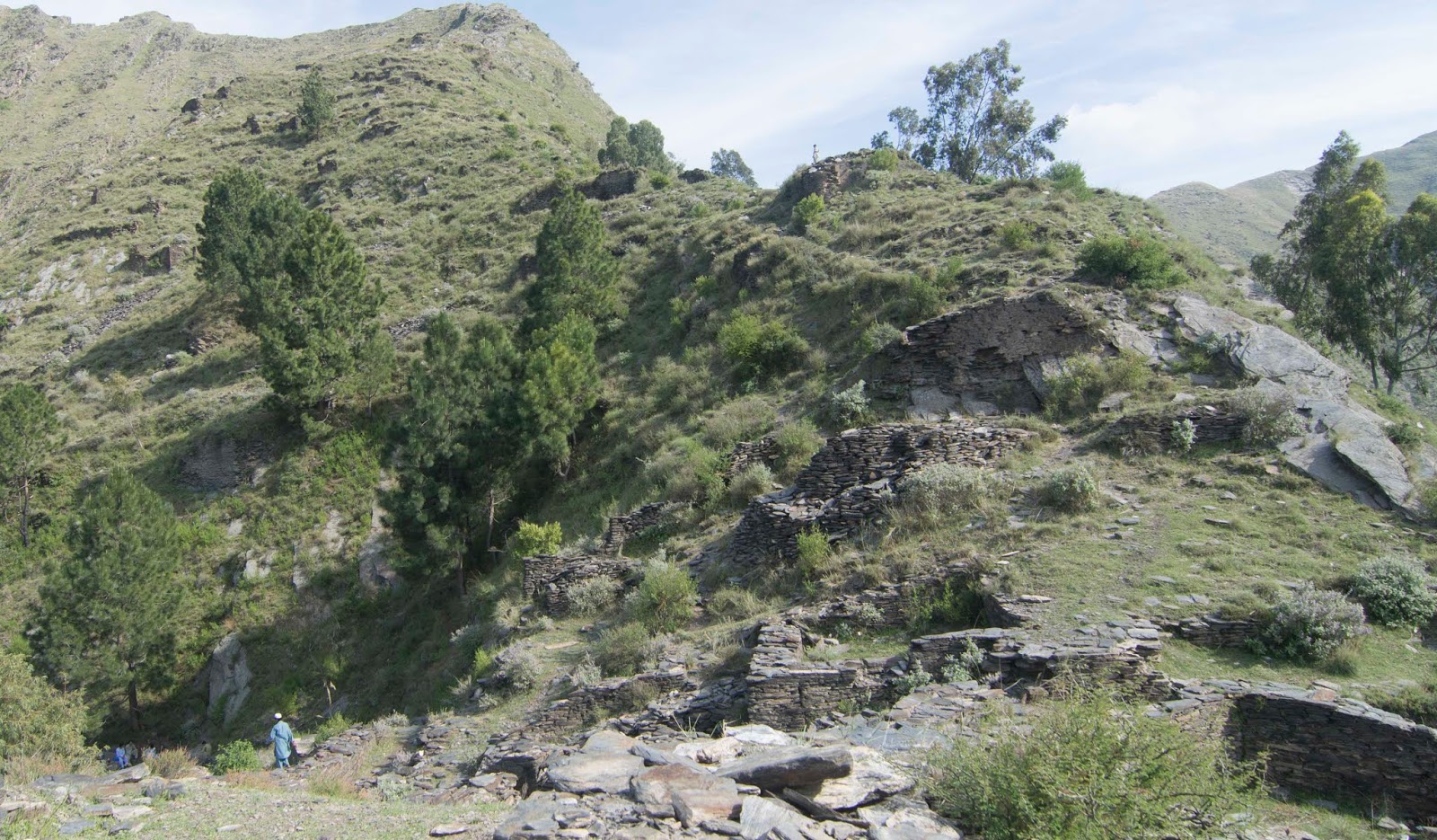
The site at Panr spans three distinct terraces, each offering a unique glimpse into the past.

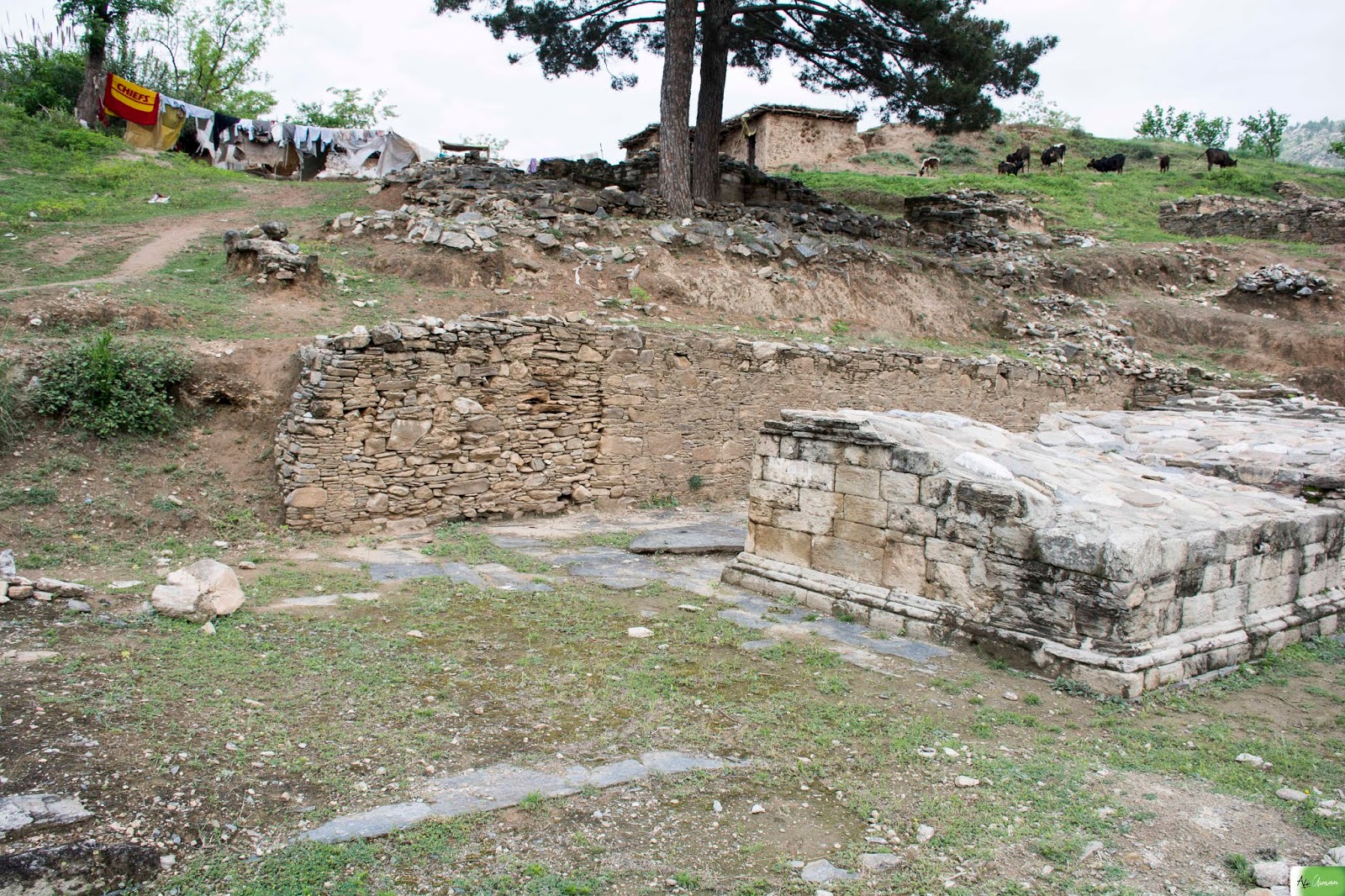
On the lower terrace, the remnants of a monastery have been found. This area was divided into a dining hall and living quarters, though only the foundations of the base platforms remain visible today.

The middle terrace, often referred to as the "Sacred Area," is home to the remains of the main stupa. This stupa, with its square base and a mound that once topped the drum, stands as a testament to the architectural prowess of its time. On all four sides of the main stupa, one can observe the foundations of standalone columns. Additionally, scattered throughout this terrace, one can find the foundations of small votive stupas.

Unfortunately, the main stupa has suffered significant damage due to the illegal excavations carried out by treasure hunters. Despite the damage, the site still exudes a sense of grandeur and provides valuable insights into ancient Buddhist architecture.

Moving to the upper terrace, one encounters the remains of the monks' cells. These cells, constructed with walls made of small diaper masonry, offer a glimpse into the early Kushan period, dating back to the 1st to 2nd century AD.

List of Architectural Spatial Components:

The monastery and stupa at Panr showcase various architectural spatial components that highlight the ingenuity of the builders:

Square Base: The main stupa sits atop a square base, providing a stable foundation for the structure.
Mound: The stupa features a mound on top of the drum, adding height and prominence to the monument.
Drum: The drum of the stupa serves as a transition between the base and the mound, often adorned with intricate carvings or designs.
Stairway: A stairway, leading to the top of the podium or the base of the stupa, allows access for religious rituals and circumambulation.
Free-standing Columns: Standalone columns, positioned around the main stupa, serve as decorative elements and symbolize architectural elegance.
Bastion: A bastion, strategically placed within the structure, offers additional support and stability to the stupa.
Square Pillar: Square pillars can be seen within the monastery and stupa complex, providing architectural variety.
Octagonal Plan: Some elements of the structure, such as the base or the drum, may follow an octagonal plan, adding geometric beauty to the design.
Corridor and Double Corridor: Corridors, both single and double, create pathways within the monastery complex, facilitating movement and providing a tranquil ambiance.

Overall, the stupa and monastery at Panr offer a captivating glimpse into the architectural brilliance and spiritual heritage of the region, inviting visitors and scholars to delve deeper into its history and cultural significance.


On the front remains of Main Stupa, on a lower terrace monastery in the background Jumbail Valley


Lower Terrace, Monastery 

Lower Terrace, Monastery

Author

Votive Stupa and Foundation of Standalone Columns

Foundation of Votive Stupa

Votive Stupa

Middle Terrace, Main Stupa and Votive Stupas

Upper Terrace, remains of Monk Cells

Lower Terrace

Platform for Votive Stupa


Foundation of Corner Stand Alone Columns

Middle Terrace

Monastery 

Monastery 


Google Earth Image