Sunday, 23 June 2019

The double-domed shrine of Gumbat-Balo Khale, Kandak Valley (2019)

*All photos are owned 
Reference of Text, A Guide to Kandak and Kotha Valleys 

The Site of Gumbat, The village of Balo-Kale, Kandak Valley, River Swat, and Mankial Mountains in Background

The archaeological site of Gumbat, which means 'Stupa' in Pashto, holds significant historical and religious importance as a Buddhist shrine known as the Great Shrine or the Great Vihara. Originally housing a relic, cult statue, or votive stupa, this site is situated at the heart of the Kandak valley, specifically on the left side at coordinates 34°37'51'' N, 72°10'46'' E. It sits at an elevation of approximately 986,000 above sea level. The site's archaeological terrace rises above the village of Balo Kalai or Balo Kale, following an ancient path leading to the Kakai-Kandao pass. Beyond the pass, the path continues into the Kotah Valley, where other significant Buddhist sites have been unearthed in recent times.

The double-domed shrine of Gumbat-Balo Khale, dating back to the 1st and 2nd century CE, stands as one of the best-preserved monuments in the Swat Valley. Due to its deteriorating condition, the shrine underwent urgent restoration in 2011. The initial restoration work was carried out by the Pakistani Army under the ACT project, and subsequent efforts were undertaken by ACT, including the excavation of surrounding monuments.

The construction of the shrine features a square-plan Buddhist shrine with an enclosed cloister elevated on a high podium. The entrance to the shrine is located on the eastern side. The external walls are separated from the inner cells by a vaulted corridor, supported by a row of cyma reverse-type brackets. The Great Shrine was originally intended to house a stupa-reliquary, a large votive stele, or a stucco statue.

The provided images showcase the state of the site before its restoration in 2012, as well as drawings and reconstructions of the double-domed Buddhist shrine. They offer a glimpse into the architectural details and layout of the shrine, the surrounding vihara (open court), and the remnants of votive stupa platforms. Additionally, there are views from inside the shrine, providing a closer look at the Buddhist courts and the foundations of the votive stupa.

In addition to its archaeological significance, the story takes a turn to highlight the kindness and generosity of a local farmer encountered during a visit to the Kandak Valley. Despite the discussion on the historical site, it emphasizes the richness of the soul found in individuals, regardless of their material wealth. The farmer, who also served as a guard at one of the archaeological sites, demonstrated immense generosity by offering bread and tea to the travelers without even being asked. The narrative sheds light on the contrast between financial wealth and the richness of one's heart, emphasizing the value of compassion and human connection. It also mentions the unfortunate circumstances faced by the guard, who had not received a salary for the past six months due to a lack of funds and changes in government.


Before Restoration of Site in 2012


The Double domed shrine of gumbat balo Khaley

Kandak Valley, Mankial range, River swat in one frame 


The Vihara, open Court and remains of Votive Stupa platforms 


Google Earth View


Reconstruction of Gumbat double-domed Buddhist shrine (1st-2nd CE) Drawings by F martore 

A conjectural reconstruction of Gumbat double-domed Buddhist shrine (1st-2nd CE) Drawings by F martore
The Double domed shrine of gumbat balo Khaley

View from Inside the  Shrine, Vihara remains of Buddhist courts and foundations of the votive stupa can be seen 

Author

Another View of the Shrine

Another view of the Shrine with Mankial Range in the Background

Double Dome

Inside View 

Inside View 

Dome View 

Inside view of Shrine 

Inside View of Shrine 

Inside View 


A small river stream flowing in Kandak Valley


Tuesday, 11 June 2019

Sirkap Taxila (2018)

Sirkap, the second city of Taxila, has an intriguing mythical origin. Its name, meaning "severed head," is derived from a legendary demon associated with the site. According to the myth, this malevolent creature consumed human flesh and met its end at the hands of the hero Rasalu. Sirkap was founded in the 180s BCE by the Bactrian king Demetrius, who had conquered the region. Under the rule of King Menander, Sirkap underwent reconstruction.

Demetrius, considering himself Greek, employed the Hippodamaean plan in designing the city, characterized by a grid-like layout. The sanctuaries in Taxila exemplify the multicultural nature of the Indo-Greek kingdom, extending beyond Punjab to include Gandara (including the Kabul and Swat valleys), Arachosia, and a portion of the Ganges valley. In the second century, Taxila became a melting pot of Greek religious practices, Zoroastrian cults, Hinduism, Jainism, and Buddhism. Notably, the Zoroastrian sanctuary at Jandial bore a striking resemblance to a Greek temple.

Archaeologists have identified seven distinct layers in the historical development of Taxila:

1. A suburb of Bhir dating back to the sixth to third century BCE.
2. The Demetrian phase of the Greek city, originating in the early second century BCE.
3. The Menandrian phase of the Greek city, emerging in the late second century BCE.
4. The initial phase of the Saca period, beginning around 90 BCE.
5. The subsequent phase of the Saca period.
6. The final phase of the Saca period, until an earthquake struck around 30 BCE.
7. The Parthian period.

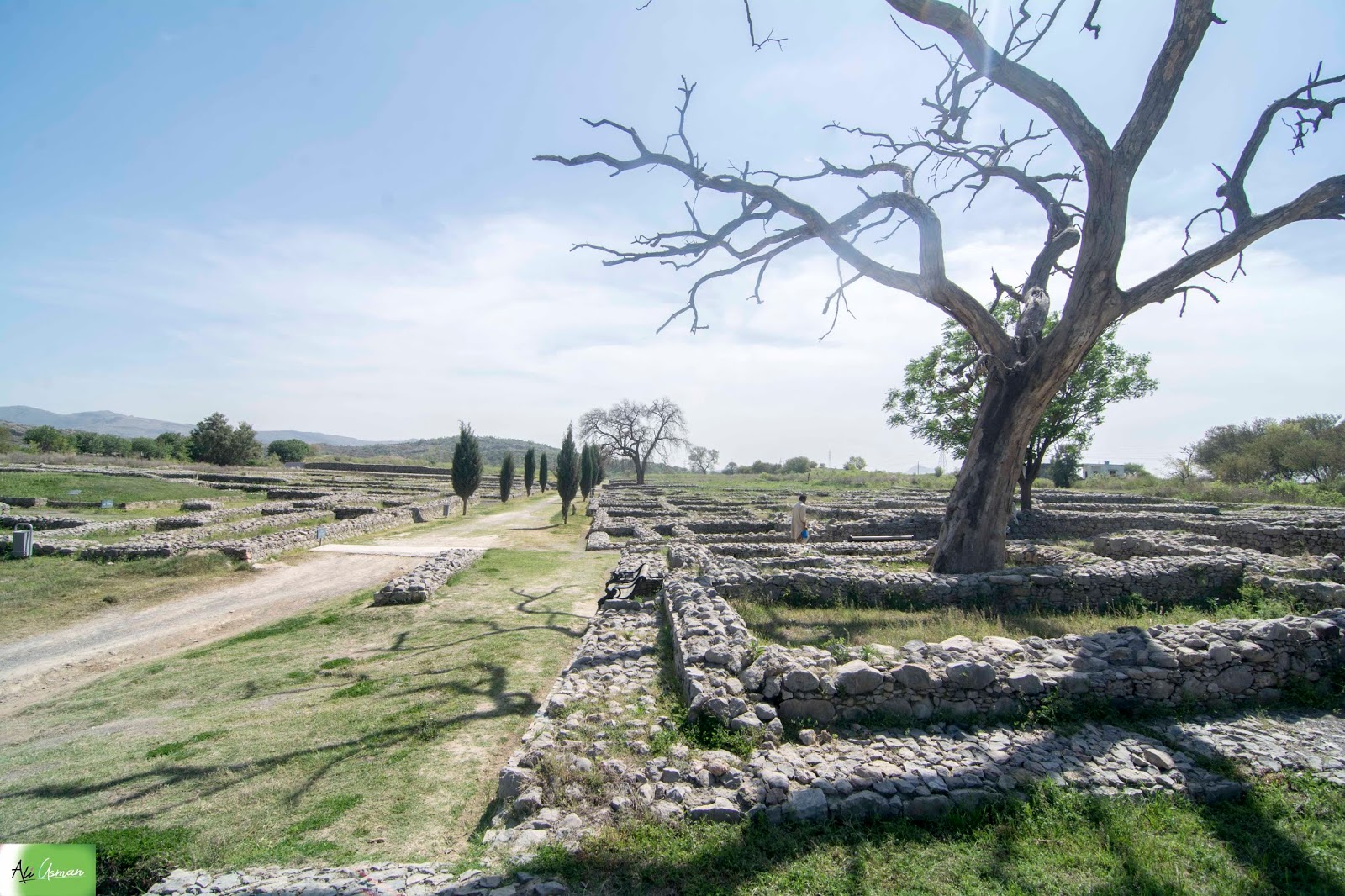
Strata 4-6 are sometimes grouped as "Indo-Scythian." Present-day visitors to Taxila primarily encounter the sixth phase, which underwent reconstruction during the reign of the Parthian king Gondophares, known as the "Indo-Parthian" period, lasting from approximately 30 BCE to 80 CE. The excavated area of Sirkap is extensive, stretching approximately 1200 meters in length and 400 meters in width. The city's protective wall, constructed during phase 5, had dimensions of 6-10 meters in height, 5-7 meters in width, and an impressive length of nearly 4,800 meters.

The walls were built using coursed rubble masonry, a characteristic feature of the Greek and Saca periods. Adjacent to the city gate, as expected, there was a guard room. The main road of Sirkap formed a straight line, dividing the town into two halves. Private houses were typically constructed with rubble masonry and coated with lime or mud plaster. These houses often featured a small courtyard, a second floor, and a flat roof. Following the earthquake that marked the transition from the Indo-Scythian to the Indo-Parthian periods, many houses underwent reconstruction with stronger walls and deeper foundations.

A Greek visitor, possibly the neo-Pythagorean philosopher Apollonius of Tyana, provided a description of Taxila, which was included in the Life of Apollonius written by Philostratus. Philostratus believed that Apollonius, the protagonist of his fictionalized biography, had indeed visited the Punjab. Much of the information provided in the account appears to be accurate. Details such as the small size of the palace, the presence of a Sun Temple, the existence of a temple situated in front of the walls (Jandial), and the narrow streets reminiscent of those in Athens have all been confirmed by archaeological discoveries.